


Thirty years on, the map has barely moved
Anyone who drives out of Cape Town's city centre along the N2 sees it within twenty minutes. The leafy suburbs on the slopes of Table Mountain give way to the flat, sandy Cape Flats, where townships and informal settlements stretch to the horizon. That geography was planned. Under apartheid, every population group was assigned its place, and the distance between those places was part of the design.
In 1994 that legal order was abolished. The new democratic state set itself the task of undoing it, and it chose decentralisation as one of its tools. Power was to be spread across national, provincial and local government, closer to the people who had been excluded for decades.
This article asks why, three decades later, the map has changed so little. My argument is that segregation in South Africa has shifted from a legal to a structural form. It is no longer enforced by the state but reproduced by markets, by land and housing policy, and by an inequality in which race and class have become intertwined. The decentralised state was meant to counter this, but in practice it holds too little power at the level where it would matter most. It follows that whether the African National Congress (ANC) or the Democratic Alliance (DA) governs a province explains far less about the persistence of segregation than South African political debates often assumes. Cape Town, governed by the DA since 2006 and still among the country's most segregated cities, is often invoked by both sides, either as proof of good governance or as evidence of its failure, yet neither reading captures the structural constraints at work.
From the Group Areas Act to the land market
Apartheid segregation was written into law. The Natives Land Act of 1913, and the Group Areas Act, and the Population Registration Act of 1950 classified people by race and assigned each group its land, its neighbourhoods and its rights.[1] Millions were forcibly removed from their residential areas of choice. The result was more than separation. It was a spatial hierarchy with white suburbs close to jobs and services, Black, Coloured and Indian townships on the periphery, and the former homelands even further out.
The repeal of these laws did not dissolve that hierarchy. It changed the mechanism that keeps it in place. Urban scholars like Ivan Turok and A.J. Christopher describe what replaced it as structural segregation. [2,3] This is a separation that is no longer decreed but produced by the land and property market, by transport networks and by unequal access to basic services.[4] Where a family can live now depends on what it can pay, and after apartheid, what people can pay still closely follows the old racial lines.
The state has often reinforced this pattern rather than broken it. Its large subsidised housing programmes delivered millions of homes, but mostly on cheap land at the urban edge, far from work and opportunity. Meanwhile evictions and the struggle over land have pushed poor households into informal settlements and backyard shacks.[5] In Johannesburg, private investment has shifted towards secured suburbs and gated estates, while the city's poor majority remains confined to its margins.[6] Market-led urban growth and a state that lacks the means, or the will, to steer it reproduce the apartheid city in a new form.[7]
This does not mean that class has replaced race. The transition from a racially exclusive society to one ordered by income did not erase the meaning of race. It fused it with class.[8] For most Black South Africans, the old racial boundary and the new economic one run along the same street. Seen this way, segregation is not only a legacy of the past but also a failure of the present, namely the failure to distribute space and access fairly in a democratic society.[2]
A decentralised state on paper, a centralised one in practice
Decentralisation does not merely refer to one type of process to explain the transition of power and influence. Political economy literature distinguishes two forms of decentralisation. The first, devolution, refers to the transfers real policy-making and budgetary power to elected provincial or local governments, which are then accountable to their own citizens. The second, deconcentration, refers to mere relocation of administrative work. This means that for instance, a regional office remains an arm of the central office/government and answers directly to it.[9] Thus, only devolution brings decisions closer to the people, and only if representative institutions, fiscal autonomy and administrative capacity are in place.[10]
Apartheid itself was a kind of decentralisation, designed to fragment the state's responsibility and keep it unaccountable to the Black majority. The liberation movement therefore wanted a strong central state that could dismantle this fragmentation.[11] The 1996 Constitution struck a compromise between the devolution and deconcentration. It created three "distinctive, interdependent and interrelated" spheres of government, national, provincial and local, bound together by the principle of cooperative governance. A dense body of laws gives this system its shape. It covers municipal structures, intergovernmental relations and a revenue-sharing formula negotiated every year.[11] On paper, this looks like devolution. In practice, three features pull power back to the centre.[12]
- Overlapping responsibilities. Housing is the clearest example. National, provincial and local government are all involved. Provinces decide where new settlements go, while municipalities have to build and service them. Nobody is fully responsible, projects stall, and residents are left waiting. For the policy field that matters most to segregation, this is the decisive weakness.
- Control over staff and office-holders. Lower spheres are constitutionally entitled to appoint their own staff, yet the national government has repeatedly sought powers to move personnel between spheres. Within the ANC, mayors of large cities have been deployed by the party leadership rather than chosen locally, and the mixed electoral system gives party headquarters strong influence over who holds office.
- Money. The provinces depend overwhelmingly on transfers from the national budget, and their spending must follow national priorities. The Western Cape and Gauteng raise more of their own revenue than other provinces, which gives them some room to manoeuvre, but not enough to set their own course.
The result is a system that combines the language of devolution with the reality of deconcentration. Provinces administer, but they do not decide on the land, housing and budgets that would be needed to reshape the apartheid city.
Does the governing party matter? Western Cape and Gauteng compared
In South African politics, the Western Cape often serves as a showcase. Since 2009, it has been the only province governed by the DA, while Gauteng, the economic heartland around Johannesburg and Pretoria, had been governed by the ANC since 1994. If provincial government made a decisive difference to segregation, it should show up here.
Census data from 1996 to 2022 show how the two provinces have changed.[13] The Western Cape's population has moved closer to the national mix. The Black African share rose from 22 to 39 percent, while the Coloured majority fell from 56 to 43 percent. An entropy-based index of how far the province's composition differs from the national one fell steadily, from 0.87 to 0.81.[14] In Gauteng, the same index fell from 0.80 in 1996 to 0.76 in 2011 and then rose back to 0.80 by 2022. At first sight this favours the DA. But two caveats matter more than the numbers themselves.
- First, these figures describe who lives in a province, not where they live within it. A province can match the national mix perfectly and still be divided street by street. Part of the shift in the Western Cape is likely driven by migration into greater Cape Town, a movement no provincial government steers. The question that matters for segregation is whether the newcomers live in the same neighbourhoods as established residents, and that has to be measured at a much finer scale.
- Second, studies that do measure segregation at ward level paint a sobering picture. Research by the Gauteng City-Region Observatory found that Black-White segregation remained high in every province in 2011. To reach an even distribution, more than three quarters of white residents, or of Black residents, would have had to move to another ward. Between 1996 and 2011, Black-White segregation declined by 10 per cent or less in all provinces, and more slowly than for any other pair of groups.[15] Measured where people actually live, neither the DA-governed nor the ANC-governed province has broken the apartheid pattern.
Statistics South Africa's own mapping of Census 2011 (figures 1 and 2) makes this visible. In its "social tapestry" maps, residents appear as dots coloured by population group, plotted at neighbourhood level. Blue dots represent Black African residents, orange dots Coloured residents, green dots Indian or Asian residents and magenta dots White residents. In both cities, the former white suburbs standout as islands, the townships sit far from the centre, and what mixing there is happens mostly in formerly white neighbourhoods.[16] Measured with a neighbourhood-level Theil index, the least segregated of the six largest metros in 2011 was ANC-governed Johannesburg, not DA-governed Cape Town.[16]
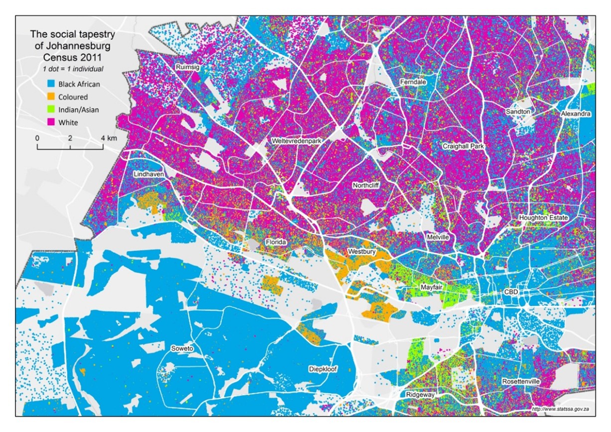
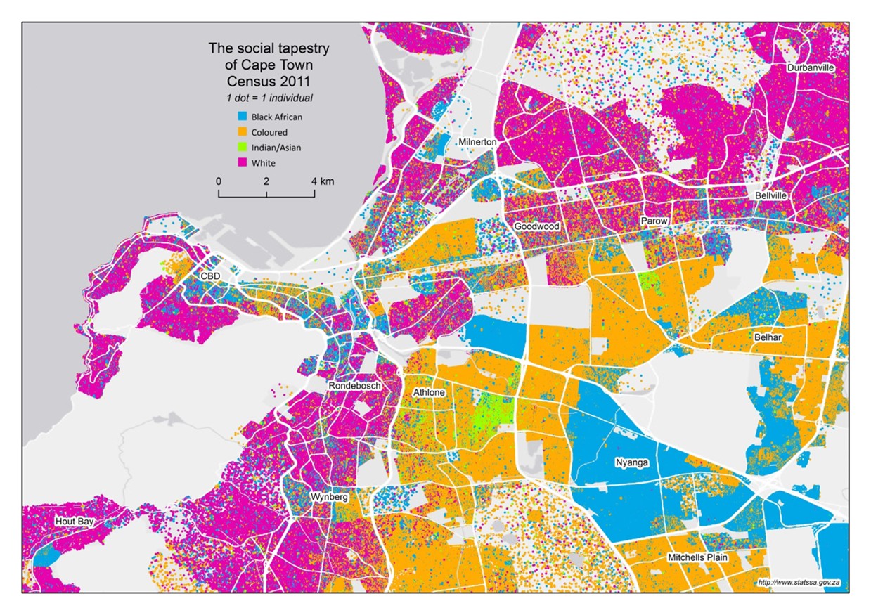
This fits the institutional picture. Given how little control provinces have over land, housing, finance and budgets, it would be surprising if a change of provincial government could reshape cities on its own. Party labels explain less than the structure all provinces share. That structure consists of a land market that sorts people by income, housing built where land is cheapest, and a centralised state that keeps the decisive levers out of local hands. Thirty years after 1994, the wounds apartheid inflicted on South Africa's cities have not healed. Healing them is not a matter of which party wins the next local election, but of who decides over land, housing and public money.
End Notes
1. Christopher, A. J. (1994): The Atlas of Apartheid. London: Routledge.
2. Harrison, P./Todes, A./Watson, V. (2008): Planning and Transformation: Learning from the Post-Apartheid Experience. London: Routledge; Parnell, S./Pieterse, E. (2010): The ‘right to the city’: Institutional imperatives of a developmental state. International Journal of Urban and Regional Research 34(1), 146–162.
3. Turok, I. (2001): Persistent Polarisation Post-Apartheid? Progress towards Urban Integration in Cape Town. Urban Studies 38(13), 2349–2377.
4. Christopher, A.J. (2001): Urban Segregation in Post-apartheid South Africa. Urban Studies 38(3), 449–466.
5. Huchzermeyer, M. (2003): Housing rights in South Africa: Invasions, evictions, the media, and the courts in the cases of Grootboom, Alexandra, and Bredell. Urban Forum 14(1), 80–107.
6. Murray, M. J. (2011): City of Extremes: The Spatial Politics of Johannesburg. Durham: Duke University Press.
7. Murray (2011): Parnell/Pieterse (2010).
8. Turok, I./Borel-Saladin, J. (2016): Backyard shack development in South Africa: The evidence and policy implications. Urban Forum 27(1),25–40.
9. Eichenberger, R. (1994): The benefits of federalism and the risk of over centralization. Kyklos 47(3), 403–420.
10. Johnson, C. (2001): Local democracy, democratic decentralisation and rural development. Development Policy Review 19(4), 521–532; Jütting, J. et al. (2005): What makes decentralisation in developing countries pro-poor? OECD Development Centre Working Paper No. 236.
11. Wittenberg, M. (2003): Decentralisation in South Africa. Johannesburg: University of the Witwatersrand; Constitution of the Republic of South Africa, 1996, Chapter 3.
12. Cameron, R. (2014): Vertical Decentralisation and Urban Service Delivery in South Africa: Does Politics Matter? Development Policy Review32(S1), 81–100.
13. Statistics South Africa: Census 1996, 2001, 2011 and 2022. Census 2022 Statistical Release P0301.4, accessed 31 March 2025.
14. Own calculation of the Theil entropy index from provincial census shares of four population groups, following Fossett, M. (2017): New Methods for Measuring and Analyzing Segregation. Cham: Springer Open. Because each province is treated as a single unit, the index captures how far a province's composition differs from the national one, not segregation within the province.
15. Ballard, R./Hamann, C./White, M. (2016): Changing Racial Segregation in the New South Africa. Paper presented at the APPAM International Conference, London School of Economics, 13 June 2016. Ward-level index of dissimilarity, census 1996–2011.
16. Statistics South Africa (2016): Mapping diversity: an exploration of our social tapestry. Neighbourhood-level maps and Theil entropy index for the six largest metros, Census 2011.


